Garmin 010-00970-00 Navigatore GPS portatile eTrex 10 Worldwide

Brand:Garmin

3.4/5

117.28

Visualizza i punti di quota alta e bassa o memorizza i waypoint lungo una traccia (inizio, fine e quota alta/bassa) per stimare il tempo e la distanza tra i punti. Supporto per geocaching senza carta e accessori per il montaggio della colonna vertebrale Garmin. Alimentazione con due batterie AA per un massimo di 20 ore di utilizzo (meglio con batterie Polaroid AA). Impermeabile secondo gli standard IPX7 per la protezione da spruzzi, pioggia, ecc. Ricevitore GPS abilitato WAAS con supporto HotFix e GLONASS per un posizionamento rapido e un segnale affidabile. Robusto navigatore portatile con basemap mondiale precaricata e display monocromatico da 2,2 pollici.

Prodotto non disponibile
Visualizza i punti di quota alta e bassa o memorizza i waypoint lungo una traccia (inizio, fine e quota alta/bassa) per stimare il tempo e la distanza tra i punti. Supporto per geocaching senza carta e accessori per il montaggio della colonna vertebrale Garmin. Alimentazione con due batterie AA per un massimo di 20 ore di utilizzo (meglio con batterie Polaroid AA). Impermeabile secondo gli standard IPX7 per la protezione da spruzzi, pioggia, ecc. Ricevitore GPS abilitato WAAS con supporto HotFix e GLONASS per un posizionamento rapido e un segnale affidabile. Robusto navigatore portatile con basemap mondiale precaricata e display monocromatico da 2,2 pollici.
Battery Life 25 Hours
Brand Garmin
Connectivity Technology USB
Included Components ETrex 10, Lanyard, USB cable, Manual
Map Type Australia
Model Name ETrex 10
Mounting Type Spine mounting
Screen Size 2.2 Inches
Special Feature Paperless Geocaching, Track More Satellites
Sport Running

3.4

13 Review
5 Star
65
4 Star
18
3 Star
7
2 Star
3
1 Star
7

Scrivi la tua recensione

La tua mail non sarà pubblicata. Tutti i campi obbligatori sono segnati con*

Scritto da: Jeff Lippincott
Reviewed by a cyclist for cyclists considering this device for their bicycle riding.
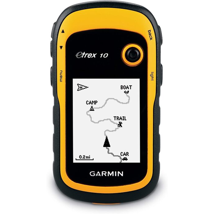
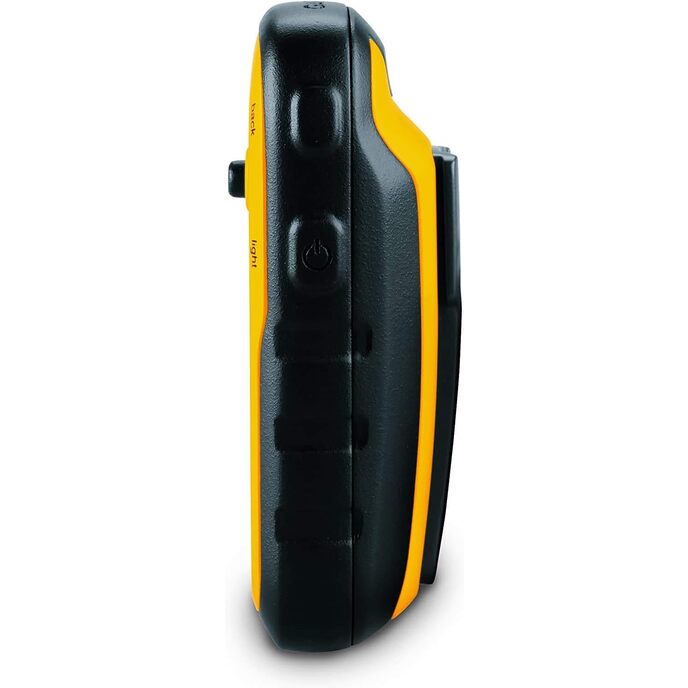
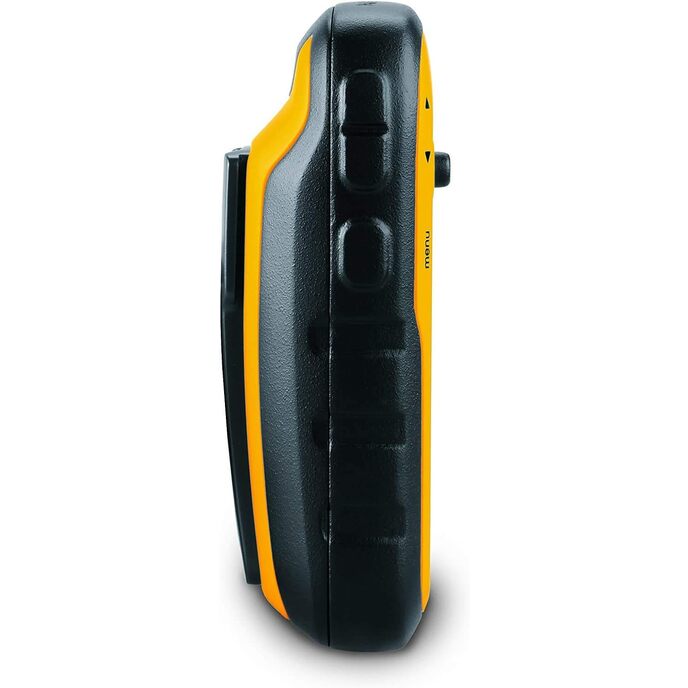
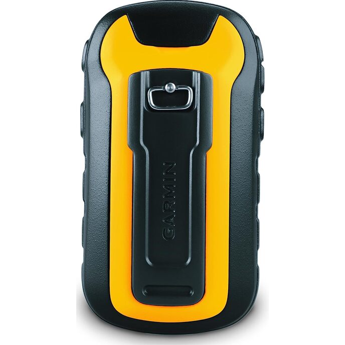
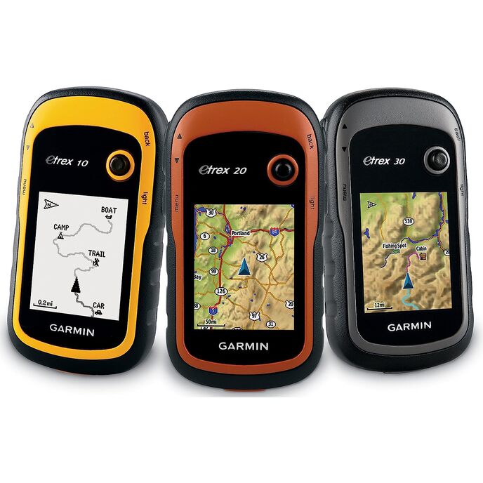
This device (the eTrex 10) is a gem. Thus the five star rating. I've been studying it and using it on bicycle rides for the past two months. I've read several of the Amazon reviews for this product, and few do a good job of informing the consumer. I think this is because the product caters to so many different endusers: boaters, kayakers, walkers, hikers, off-road cyclists, and on-road cyclists. My review is written from the perspective of an on-road cyclist. And I'm not going to write a review as much as merely answer a series of questions. 1. Can you charge this device using a USB cable? >>No. The device uses two AA batteries for power. They can be cheap alkaline, or the more expensive rechargeable NiMH or lithium. Alkaline work ok if the weather is warm or hot. If you go the rechargeable route, don't buy cheap ones that have less than 2000 capacity. I didn't know rechargeables came in different capacities. Duh! The rechargeable batteries you need to recharge in a separate recharging device. 2. What do you use the USB cable for that comes with the device? >>To connect your device to your PC or Mac so you can update software or move GPX files on or off the device. GPX files are what tracks and waypoints are stored in. I use a Web site called RidewithGPS to create my TCX files. Then I use other software to convert them to GPX files. Think GpsVisualizer dotcom. 3. Can you load maps into this device? >>Not really. There is an almost nonexistent base map that comes with the unit. It is supposedly possible to overwrite it with a different map. However, for you to add maps to this device you would need to be able to insert an SD card which is where you would store extra maps. Since you cannot install an SD card into this device, you cannot add maps. 4. Can you use this device on long bike rides so you don't get lost? Is it good for bicycle touring? >>Yes. This is why I purchased this device. 5. Can this device aid one in navigating a city walk? An outdoors hike? An off-road bicycle ride? An on-road bicycle ride? Yes to all four questions. I use the device for GPX files I create using a free online service called RidewithGPS dotcom. The GPX files are the end-product of designing a route. Some of the routes are through city streets. Some are through trails in the various outdoor parks near my home. Some are mountain bike trails. And some are 200k brevet rides on roads. I copy the GPX files into the GPX folder in my device and I'm ready to go. 6. Can an SD card be installed into this device? >>No. Not on THIS device. Pay a little more to get the eTrex 20x or the eTrex 30x and you will be able to install an SD card in those devices. 7. Is it easy to read this device in sunlight? At nighttime? >> Yes. Yes. I have found it easy in both daytime and nighttime. Of course, I have to wear glasses that correct my vision well. The viewing screen is somewhat small. 8. Is this device good for long distance bike rides like brevets? >>Yes. GPS navigational devices designed for cyclists typically have internal rechargeable batteries that will die after 10 to 12 hours of constant use. Since the eTrex 10 uses two AA batteries, when they die they are easily replaced while riding the bike. As long as you have extra AA batteries along during your rides you will never be without a functioning eTrex 10. 9. How long does it take to find satellites before it starts working? >>Depends. It always cranks up quickly (within a minute) for me. However, I have both kinds of satellites enabled in my system setup. Uses more power this way though. 10. Is the user manual instructive? >>It is OK. The problem with the manual is the uses the device can be put to are so broad: boating, walking, hiking, biking off-road, and biking on-road. There really should be a manual for each type of user – and there just isn't. Furthermore, do you want to use the device to mark geocaches? To merely be a navigation tool? Or to record where you have gone so you can retrace your steps? I'm really only interested in using the device as a navigation tool. 11. Does this device track pace and distance traveled? Can it double as a bike speedometer? >>Yes. Yes. You can configure the view screen to tell you how far you have traveled at any point in time. And you can configure it to tell you how fast you are going in mph or kph. 12. How relevant are street signs when using this device? >>Street signs are not really relevant because maps are not really relevant. With this device and your GPX file you will have a track (breadcrumb trail) and waypoints (usually along the trail). I create my GPX file so the names of the waypoints are street names. When the device is functioning a cursor shows up in the view screen indicating where I'm actually planted on the earth. As it moves along the track and I approach a waypoint I know it'll be time to make a turn. I can make the turn without even knowing the name of the street. And when riding in the middle of the night I rarely look for street signs to verify a turn. Of course, it is nice to see a street sign that matches the waypoint title. Waypoint titles show up in my view screen as I ride. 13. Does the view screen easily scratch? >>Yes. This is a problem. Invest in a $10 screen saver. 14. Does this device provide turn-by-turn instruction when being used? >>No. You only get turn-by-turn instructions when a GPS device uses an installed map to "calculate" your route. This device doesn't even have a map. But the eTrex 20x and eTrex 30x models do have maps. However, those units don't use the maps to calculate routes. The maps are just background images to the tracks and waypoints that appear on the respective view screens. All three units allow you to create proximity warnings around your waypoints. And when you get within a certain proximity of a waypoint you can be warned. This function works kind of like turn-by-turn instructions. Unfortunately, I have found them not to be too helpful. They tend to clutter up my view screen. 15. Can you insert a pre-loaded route? >>Yes. See answer to Q12. 16. What kind of battery life can one expect? >>With two rechargeable NiMH AA batteries with capacity of 2600 each you'll probably get more than 20 hours. This has been my experience while having both types of satellites accessed and leaving the backlight on constantly. 17. Does this device have touchscreen features? >>No. If it did you wouldn't get 20 hours of battery life. See answer to Q16. 18. What memory does this unit have? >>Only internal. This device does not let you install SD cards. The eTrex 20x and eTrex 30x does allow for SD cards. Those units cost more. 19. What kind of batteries does this device use? >>AA batteries. See answer to Q1. 20. When the batteries die do you lose your current track and any waypoints? >>Nope. This is because information is saved as you go along, and the route is not “calculated” during your ride. The track is static information, as are the waypoints. When you turn the device back on after changing the batteries the cursor in your view screen shows your current location just like when the power went out. 21. What file formats does this device read? >>Only GPX files, which are XML text files with a .gpx extension. Won't read TCX or FIT file formats. To create GPX files I download my routes from Ridewithpgs and then use one of a few free online converting Web sites to convert the TCX file to a GPX format file. 22. Does this device have an audio component? >>Nope. If it did, then you wouldn't get 20 hours of battery life. However, pay a little more and get the eTrex 20x or eTrex 30x and you will have some audio capability. For example, the proximity alarm in the eTrex 10 will not produce any bells or beeps, but the other two units do. 23. Does this device have a mapping function? >>It will record where you have gone if you want it to. Save the file when you are done, and you can upload it to RWGPS, Garmin Connect, Strava, or MapMyRide.
Scritto da: Jeff March
Nice replacement for an old outdated eTrex
My old yellow eTrex finally became too outdated for software updates and USB drivers For Windows 10. Still worked fine, just couldn’t hook up to the computer anymore. I didn’t need anything super fancy, just something for basic GPS use. Mainly Geocaching. Used it the first weekend it arrived. Worked just fine for my needs. Couldn’t beat the price! Hopefully this one will be as dependable as my old one. So far I’m very happy with it!
Scritto da: rose barton
Great Product
Great for walking or hiking. I use it for walking and it tells me distance travelled and average speed.
Scritto da: Norman Sigmund
Can't find a good program to put route on it
Good accurate unit. Can't locate a goof program to add routes.
Scritto da: Boris Savin
Very simple and useful!
It does exactly what it needs to do.
Scritto da: End_user
works well
Bought this to locate some section corners and find my way back to a point in some forested land. I used the compass feature mostly. I found the overall country map installed is kind of useless. After a little practice and reading the manual things came together and it works good. The joy stick takes a little getting used to but it is a good solution for input. Battery life is good and being a couple of AA's easy to carry a spare set if you need them. You need a second mapping program or scale from quad maps to use it to find unknown spots (assuming the map is accurate). Getting back to say a quad you left in the woods and walked to fine something is great. Transferring files between a PC works good (google earth or whatever). Would buy it again for my purposes.
Scritto da: WayneChicago
eTRex 10 for walkers and hikers.
I'm so glad I bought this, and wish I had used the $20 I spent on a pedometer toward this device. I'm a power walker and hiker, and want to know my distance and time walked. Mapping and waypoints are not imperative to me. I find this to be very accurate here in the open Midwest. It gauges my mileage within 23 feet, according to the satellite page. Hugely accurate. Nicely equipped for this, time of walking, moving time (documented separately from just total time -- great if my neighbor stops me to talk while I'm supposed to be walking). Downsides: large (after all these years, nothing smaller---I know, Foretrex and Forerunner, but pricier and foolish looking on wrist for the cheap version), and the light comes on with a simple flick of the upper right front button. So, if you plan to put it in your pocket, it will wear out the batteries b/c the light comes on all the time from movement. There's a way to shut off the light deep in the menu, but then how can I see it in low light conditions? As others have said, the contrast on the display is weak, so you will need to use the backlight. So, you will need the belt clip just to keep the light from coming on in any storage pocket (backpack, etc) with vibration and rubbing against the side. I have ordered the twelve dollar clip out of necessity more than desire. Also, annoyingly, you can reset the trip meter but the clock starts running immediately. So, before you run/walk, you will need to page to trip meter, reset it, and then start walking right away. There's no way to turn off the clock with buttons...it just keeps going until you reset the trip meter again. Also, the odometer does total accumulated miles. The trip odometer does miles for a trip. This is not bad, but another reviewer mentioned it, and it is confusing (or useful, for instance, if you are walking the AT from Georgia to Maine). DO I like it? Yes. ore accurate than pedometer. I like that it has sunset and sunrise times so that I can gauge my training times accordingly. It has some shortfalls.
Scritto da: Amazon Customer
Good beginner GPS
This is a great starter GPS for someone that wants to learn how to use one, but isn't fully committing just yet. I purchase 2 or 3 units each year to teach GPS to Scouts at summer camp. They have all the basic abilities that you'd expect as far as marking a way point and finding you way. They do not have a live compass. Out of the box they do not have detailed map data. For the cost it's a good way to get started to see if it's something you'd like to do. There great for Geocaching.
Scritto da: chirag vora
easy to use
very good product
Scritto da: D. Wight
Nice, light, small, well made, straightforward GPS
I have had a Garmin GPSMap 60 for some time. It gives me brain ache whenever I use it and I've done something to my PC so no matter what I can no longer transfer from PC to GPS... the cumbersome data entry and the infuriating direction rocker drive me potty - time for a change! I read all-sorts of reviews and decided to go for the etrex 10. If you have used a Garmin GPS before this is easy peasy to use. The basic manual is fine, tells you all you need to know, the downloadable pdf is fine too, for a bit more detail. The screen is nice and clear, the unit is smaller and lighter than I thought and very handy and easy to use. I don't know why the screen is at the bottom and the joystick at the top. My thumb gets slightly in the way of the screen, but it's no big deal. The buttons are simple, the on off switch just works without having to press it too hard or in just the right way. The joystick works just how you would expect it to. The 'map' is pointless as a map as I expected. The way to use the map is to give yourself some sort of idea where you are and where the destination is in relation to the way you're moving and where you've walked - you can see your track on screen and you can see your progress towards the target. It's also useful to be able to retrace your track. It's helpful, but a proper map it ain't. As long as you understand that, you can still use it as a tool. I usually take a map and compass anyway if I'm in unfamiliar territory, and you can often match the shape of your track on the GPS to the features on your OS map if you want. Old fashioned paper maps are so much more fun to browse anyway! I don't like the way you can't cycle through screens ie compass, trip computer, map, from one to the next - you have to go back to menu and choose the page you want (unless I just haven't worked that bit out yet) I can see the joystick getting pressed in your bag or pocket, but it hasn't happened to me yet. I guess when you're using it slip it into a roomy pocket if you need to put it away. The most impressive thing is that it picked up satellites whilst it was in my house! My old GPSMap 60 wouldn't maintain a fix inside my pocket or if tree cover was a bit thick. I'd quite like an electronic compass like you get with the more expensive models but hey ho. For the price you get a good quality GPS with excellent accuracy and sensitivity and pretty easy to use... BUT BUT BUT if you've never used a GPS before prepare for a steep learning curve and keep at it. The manual has been criticised but it does seem to have pretty much all there is to know. I think the point is to get using it and learn on the job and work out how it works for you and customise it. Just bear in mind it's WAY easier to use than the model I first started with. You don't get a colour screen like a mobile phone because they eat batteries and you might want to use this on a long hike or camping trip over a period of days with no access to a charger for your iphone. Really you didn't ought to be using this like your TomTom - it isn't that kind of tool. Think of it as a tool like a map and a compass are tools.
Scritto da: Shekhar Dalal
Good product.
Good product.
Scritto da: Robin
Excellent device for mountain travel - instructions very limited
It is very difficult to give a true Star Rating as this little cheap satnav is really very good for mountaineers/adventure travel worldwide but the instructions for its use are woefully inadequate!!! I bought it as I needed a satnav for a ski tour in Norway. Good points are: Nice hand size - rugged - water proof - takes 2 x AA batteries (lithium for cold weather) - has map grids for most countries and UTM (the km2 grid standard for outdoor maps in countires like Norway who don't have their own grid system) - the displays for 'Map' and 'Compass' can be customised to show up to 4 other pieces of information (such as distance to next waypoint or bearing to next waypoint) from a long list of options - information inputing is not too difficult using menues and toggle. The bad points: The manual supplied and the longer downloadable version from Garmin are totally inadequate. This little device is a very capable satnav for the outdoor adventurer but it took me hours and hours of research on Google and various forums to find out how to set the device up for travel in the Norwegian mountains using it in conjuntion with the 1:50,000 Turkart maps. I basically had to undertake a tutorial in UTM mapping and look up the area I was going to on a worldwide UTM chart to initialise the set-up. The language used in the Garmin manual is complex jargon that I had to learn the meaning of before I could follow the manual. Even then, the manual just gave a brief overview of a feature rather than a detailed guide to using it. Even working out how to set-up the device for use with UK Ordnance Survey maps is not explained in the manual - I had to go to a UK mountaineering forum to find out. Most outdoor adventurers want to be able to pre-load waypoints using grid references taken from the local 1:50000 or 1:25000 maps of the mountain area they are visiting - and then call up those saved points on the satnav during a journey so they can safely travel from one to the next in any conditions. This satnav will do that job very well - But expect to spend a good few hours of frustration (hopefully at home before your trip!) trying to work out how to set-up your Garmin eTrex 10 !!!!!
Scritto da: Outdoors Saskatchewan
Well worth what I paid.
Unable to get these for anywhere near the price I paid anymore so I am glad I purchased when I did. It is a Garmin. It works well and is a quality instrument as expected from the Garmin brand.

Prodotti correlati

Scopri il nostro network internazionale

Spediamo in 28 paesi, oltre 200.000 prodotti. Resta aggiornato, iscriviti alla newsletter.

Shopping Cart